Published November 19, 2020 by the Vermont Community Newspaper Group
Q: What are the long earthworks in the East Woods Natural Area in South Burlington connected to?
A: It takes only ten minutes for me to walk through the East Woods Natural Area to get to the long earthworks. But the walk along the trail is also a walk back in time to the late nineteenth century when this area was poised to significantly change how people traveled.
I start at the Swift Street parking lot, where I’ve navigated some of South Burlington’s 100 miles of roads to park my twenty-first century car. The current road network gives city residents access to thousands of places very quickly, but it’s very different from the horse and buggy days I’m about to dip into.
As I start on the trail, I’m quickly engulfed by the tall white pines. Soon, I stop at a blow-down that’s been cut up, and count about 100 rings. The first 20 are noticeably wider than the later ones, signaling abundant sunlight as it got started. That fits with the old photographs of this area as all farmland in the early 1900s.
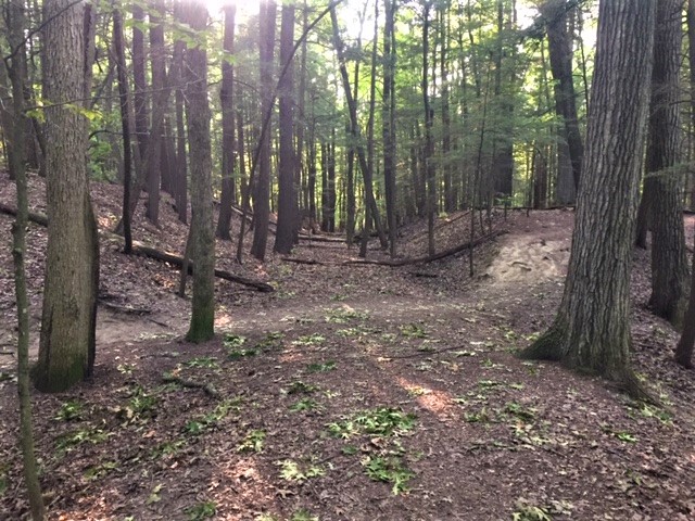
After ten minutes of level walking, the trail starts a sharp descent that also brings a dive deeper into the past. Just ahead are the earthworks I had heard about – two parallel mounds stretching off to the left. They are much larger than I expected: 8-10 feet high and about 30 feet wide at the base, and separated by flat-bottomed troughs about 15-20 feet wide. Local history tells me I’m looking at some nineteenth-century railroad beds, but I can’t quite interpret it all. So, I get out my LiDAR image to help me.
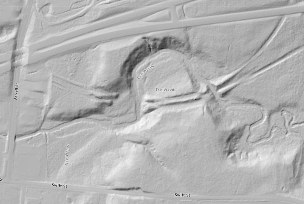
LiDAR is a new type of hi-tech aerial imagery that uses pulses of laser light to let you see “through the trees” to the ground surface below. The LiDAR image of East Woods shows the ground features in striking relief and makes them much easier to understand. Besides the roadways that frame the photo, the image focuses on a broad northerly bend of Potash Brook with its steep banks crossed twice by some sweeping, parallel linear earthworks.
As I look back and forth between the LiDAR image and the undulating mounds and troughs around me, I begin to understand that the railroad beds ran through the troughs, not on the mounds. The mound tops are the original ground level and the troughs were cut down through that. If I follow the rail beds as they cross the trail and go to the right toward the brook, I see that they are built out over the stream bank and stop suddenly at the brook edge. Looking carefully, I can see matching embankments on the brook’s other side. Suddenly all the pieces make sense. I can erase the trees in my mind’s eye and see how it would have looked back in the 1890s.
The LiDAR image shows the two rail embankments on the brook’s farther side clearly – they spread apart just beyond the brook edge. The northerly one bends off toward Essex Junction where it was to join other regional rail lines. The southerly one goes east and then eventually curves south toward its goals of Hinesburg and Bristol. Both Hinesburg and Bristol were bypassed when the original railroad was built into Burlington around 1850, despite both towns being water-powered manufacturing centers with populations larger than Shelburne or South Burlington. When this rail line was being planned, public transportation from Hinesburg to Burlington was a daily horse-drawn stagecoach trip along what is Rte. 116 today. The stagecoach schedule says it was a 3-hour journey over the 13 miles of dirt roadway (not paved until the 1930s). The newly planned railroad trip would have taken 15-20 minutes – a dramatic improvement for manufacturers and day passengers alike. But after construction began, the financing fell through. The rail beds to Hinesburg and Bristol were never finished, nor were the tracks ever laid. The rail line to Essex Junction ran for just a few years. The embankments and cuttings here were abandoned, and eventually the forest claimed this area.
Continuing on the trail as it hugs Potash Brook’s northerly loop, I eventually come to the west end of the same undulating mound system. Here again the cuttings are the rail beds. As they approach the brook, they are built out level to meet the rail bridge crossings to the Burlington waterfront.
As I continue the trail circuit, I leave the nineteenth-century earthworks behind and return to the present-day and feel the refreshment that forest time can bring. Though the mounds and troughs are certainly intriguing, I realize that maybe it was a lucky thing for us that the 1890s rail lines were abandoned. If they hadn’t been, we might not be able to walk through what has become a lovely forested natural area.
Copyright 2020, Jane Dorney
